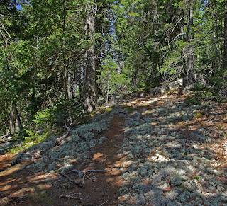
A beautiful sunny day with temperatures in the 50's.
Baker Hill and The Ledges was another suggestion from Scott. We found Baker Hill easily enough on Punkinville Rd. in Sullivan but we were not sure where the ledges were except that they abut Baker Hill. I won't attempt to describe our route because we wandered over several trails ( only the first was named and we didn't see the overlook)and weren't always sure where we were. We came out on the road up from the parking area we had started at. this was a very pleasant walk with woods, open areas, a pretty pond, and lots of new growth.
We then headed back on Route 1 but stopped at the rest area to climb Tucker Mtn. across the road. This was a short but fairly steep climb with the views from ledges near the top rather than from the summit.
Subscribe to:
Post Comments (Atom)


I'm glad you enjoyed it! You did well to find Long Pond and the alternate trail out to the street. When you left the well marked trails for the narrower ones flagged with tape you entered the Ledges parcel. I have no idea what the boundaries of either parcel are because there are no maps available that show them. Some of the land around Long Pond is owned by the water district. I'd say the view from the Baker overlook is a bit better than the one from Tucker because the ledges are steeper. I had my doubts that the Ledges parcel even has prominent ledges because they don't show up on the aerial photos. But their newsletter says, "The preserve is nicely forested with numerous dramatic granite ledges and outcroppings
ReplyDeletethat offer views of the Acadia Mountains to the south and Schoodic Mountain to the north." So they must be there. I expect in a year or two they'll have the Ledges trails better marked and mapped.
I'm really scraping the bottom of the barrel coming up with places for you because you know about 98% of the same trails I do.
How about Lead Mt.?
Pigeon Hill on Petit Manan Point in Steuben has some great views but the hike is a little short by itself. Maybe you could hit one of the shore trails while you were there.
Hatchet Mt in Hope is also a shorter hike but again you could grab another one the same day like I did here: http://www.bangordailynews.com/detail/104584.html
Have you done Fletcher Bluff out behind Chick Hill? I'd have to draw you a map for that one.
Have you been to the Hidden Ponds at the foot of Tunk Mt? I know you've done Tunk but not which way you approached it.
Also I looked at your photos of Tunk and I'm not sure if you found the north overlook. At the little green building atop the Mt. you drop down into the woods on the north side of the ledges, follow the trail perhaps 800' until it comes out in the open then follow the trail off to the left slightly maybe 300' more.
ReplyDeleteHere's the overlook from below:
http://www.panoramio.com/photo/23237163
Hi Scott
ReplyDeleteThanks for all of your suggestions. The purpose of starting the blog was to get suggestions and to this point you are the only one to offer them. I appreciate it. We did find the north overlook of Tunk. There was a forest service guy up there when we were (checking the relay facility) and he clued us in. I don't remember which approach we used but will try the one you mentioned as I don't remember the ponds.
Got the Pathmakers book from the library-very impressive- I will get one for myself. Amazing how many abandoned trails there are to explore ( though some are very short).
Thanks again