
This was our second attempt to find this trail described in Steve Perrins book "Acadia The Soul Of A National Park" but not found on any of our maps (I added the purple sections on the above map from Perrin's book) . The first time we followed his route clockwise from the end of the Dorr S. Ridge Trail and were not able to find the trail past the stream. This time we went up Canon Brook to see if we could find it from the other end and were successful.
A beautiful sunny day with temperatures from the mid 40's rising to the mid 50's-ideal. We started at the trail head on Rt. 3 . Canon Brook is an easy trail until you cross the stream near the A. Murray Young Path when it begins to climb and becomes steep and rocky but is a very pretty trail. This was the hardest section for Kelley and she twice needed a boost.

The trail then becomes less steep crossing sheets of granite.

Looking back down the trail

Crystal clear water in a pool Kelley enjoyed

As you near the intersection with the Cadillac Mtn. Trail the Canon Brook becomes easy again.

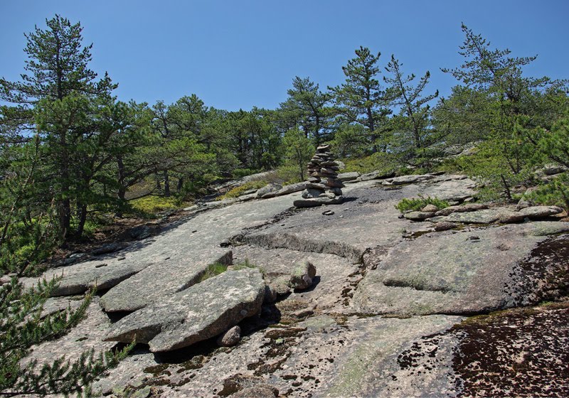
We turned south on the Cadillac Mtn. trail. We had been warned there were no markers near the trail but a after a little searching off trail we found our first cairn and were on our way. The trail shows little wear but the cairns keep you on track.
This monster is not typical
The trail is quite enjoyable as it slants down across the mountain. It is fairly open for the initial section and offers some nice views.

Eventually it dropped down into the woods and the trail was even less distinct but the cairns kept us on track.

Eventually the trail began to rise again and after it showed no signs of dropping back down we decided we were off course. We back tracked and found an unmarked trail ( no cairns or tape) that seemed to be going in the right direction. We followed it to the stream and were across from the area we had come too on our first attempt! We crossed the stream and took the extension back to Canon Brook and that back to where we had begun. Great hike 3-3/4 hours

Hey John, if you like abandoned trails you might enjoy this book that tells the history of all of them in Acadia. You might even find it in a book sore in Bar Harbor.
ReplyDeletehttp://www.amazon.com/Pathmakers-cultural-landscape-historic-conditions/dp/B00313J73Y/ref=tmm_pap_title_0
Here's a place you might enjoy in Sullivan. The Long Ledges parcel isn't well marked like Baker Hill, but it is a fun place to tromp around just the same.
http://www.facebook.com/album.php?aid=172242&id=688384830&l=8ab451374a
Make that a book "STORE"!!
ReplyDeleteThanks Scott.The library has it. Right now I have " Trails of History" which gives the history of the trail system but not much about finding them.
ReplyDeleteWill check out your other suggestion. We have done most of the trails in the nearby Donnell Pond area.
Hoping to try this today. Just got Steve Perrin's book (it must be because I read about it here) and loving it.
ReplyDeleteHi Blake- I ended up buying that book- glad you like it- would like to hear how you do finding the trail and what you think of it. I never saw the 3 signs he mentions-
DeleteNice find...I have read about this trail and plan on looking for it this coming spring, if all goes well. Love the photos also.
ReplyDeleteThank J.R. as stated this was easier to find from the Cadillac Mtn. Trail but we have also found it from the other end. Let us hear how you do. It's a nice trail.
DeleteHi, All. There is also an approach from Otter Creek. Follow the trail down from Rte 3, and just past the swimming hole it heads up to the left; much easier to see than the trail across the creek when you come south from Dorr. Perrin's book is a great intro to this and other abandoned trails. The best is the old Goat Trail up Pemetic, taken either straight up from Jordan Pond or from the road around the pond--look for the cutoff metal rongs on the rockface adjacent to the road.
ReplyDeleteThanks for adding info. I ended up at the swimming hole also
DeleteLove this info! Can’t wait to hike it- is the swimming hole actually enough for humans can take a dip? Is the picture of the sweet dog from the swimming hole or another pool on the trail? Thanks!
ReplyDelete