
A nice day but there still seems to be ice everywhere. This was a try at another place. The start up Taylor Rd. was encouraging- no ice- even a little muddy. We decide to try the ski trail toward the bog but that turned out to be difficult rough icy surface. Back on the road/rail bed we again came to ice covered snow.

Still, if I stayed in the middle it wasn't too bad. Then we took the short trail to Pine Pond- still frozen

When you are back to the road/ rail bed it gets a bit confusing. The map shows the rail bed curving off to the east but there is a trail that looks much more like a rail bed that goes straight ahead- the part that curves looks like a woods road. We went straight ahead.

There was less snow and pretty good walking. And then there was no snow

and I found this lichen

This trail proved to be very variable as we came to a very wet section that we were barely able to skirt ( ponds on either side and probably impassable in spring) and then heavy snow and lots of blow downs.

At this point we turned back. When we came to an unmarked side trail- not on either map I had- Kelley wanted to take it so we did. At first it wasn't bad.

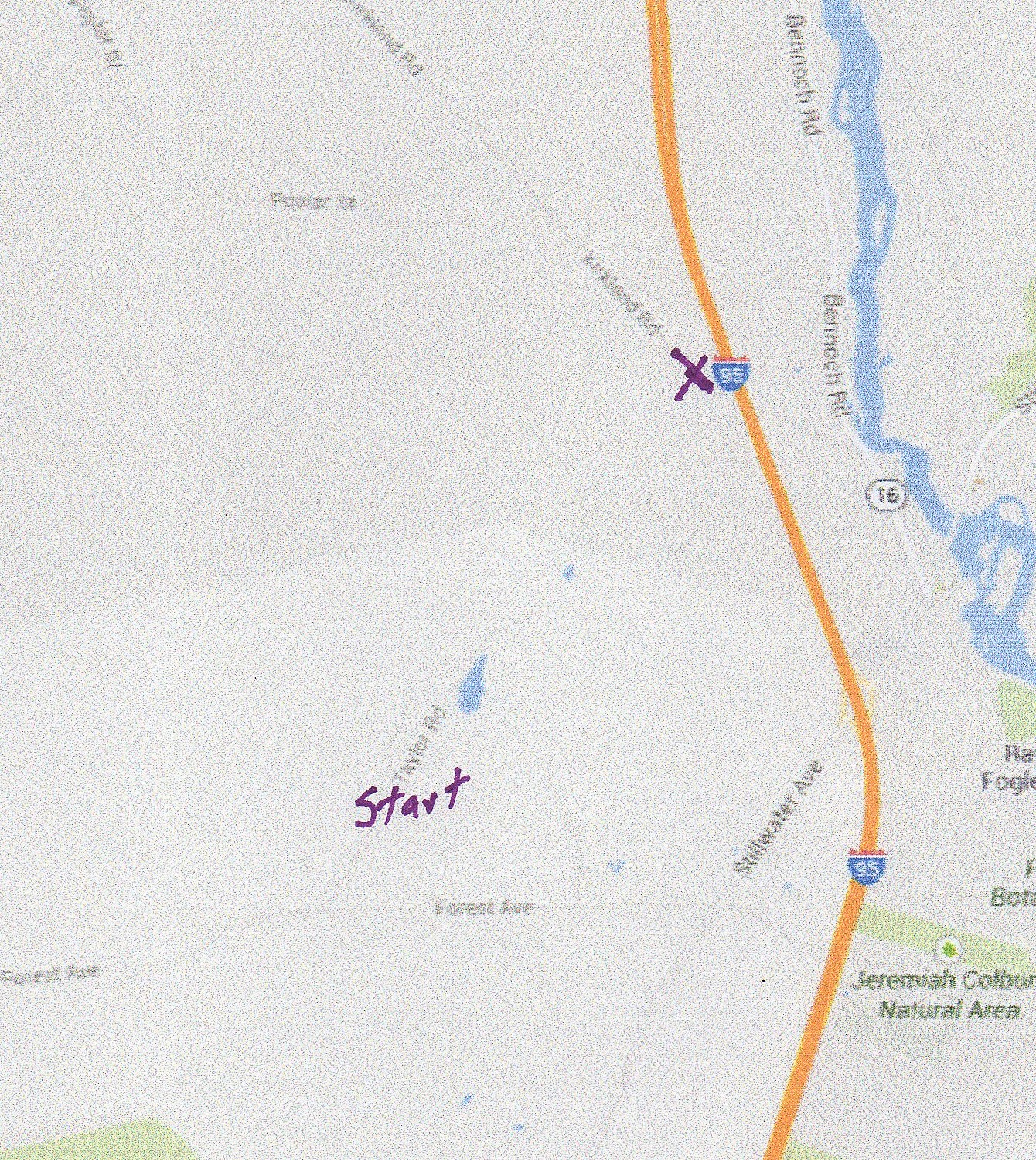
but soon we were in a marshy area with crust that broke leaving me in water above my boots. Of course, none of this was a problem for Kelley. We came to another trail which I thought I knew but I was wrong. After awhile we were in even worse conditions. There were some of the blue diamonds they use to mark the ski trail but no one had been on the trail and that was suspicious. We crossed a beaver dam that I thought we had seen on a previous hike and now I could hear traffic. Thinking we were near Forest Ave., we head for it with the plan of taking the road back. It was not Forest Ave. but the interstate. OK, I had never been near the interstate on any of many previous hikes here- no idea where we were. The trail continued, roughly parallel to the highway and we were still seeing those damn blue diamonds. It got even wetter with water several inches deep on top of ice. Finally we came to a road I hoped was Forest Ave, but it didn't look right. I flagged down a couple who told us this was Kirkland Rd. in Old Town. We had been headed away from where we wanted to be. They asked where we had started and offered us a ride which we accepted.
Map of the area showing where we started and where we ended up. This is probably my worst display of a poor sense of direction.
Two hours after starting out we were back at our car and glad of it. I was wet to my knees and also quite dirty. Kelley was as she always is.

Wow - you did have an adventure! Good thing you met up with that nice couple who gave you a ride.
ReplyDeleteHi Linda- yes, it would have been a long walk along the road- not fun.
DeleteYou never told me you had a poor sense of direction! :) Thank goodness you came across someone-- that would not have been just a "long walk". When you and Kelley have adventures, you have real adventures! When I saw one of the early pictures with the two tracks, I thought you were driving...
ReplyDeleteHi Faith
DeleteYes, someone had a vehicle back there.
an adventure for sure!
ReplyDeleteHi penbayman- thanks for visiting and commenting
Delete