The Rest of Our Hiking Pictures Can Be Found Here

Finding Trail Descriptions

So as not to repeat myself excessively, I am reducing the amount of description of trails that have already been posted. Please use the search function ( upper left) to find older posts which have more detailed trail descriptions and pictures. You can also use this to find specific hikes either by trail or mountain.


Click Pictures for a Larger View


Monday, June 28, 2010

6/27/10 Flying Mountain/Valley Peak Area


We started from the parking area on Fernald Point Rd. on the Flying Mtn. Trail. This trail is mostly easy except for a spot with large boulders that Kelley needs a boost over. You get nice views with little effort and we met some nice people up there.

Flying Mountain Overlook

The trail then dropped down to Valley Cove

and a chance for Kelley to swim.

The trail, called either Flying Mountain or Valley Cove which runs north along the water has some very large boulders that Kelley couldn't negotiate so we tried bushwhacking around but mostly ran into more cliff like formations.

We then tried to bushwhack on an angle up to the Valley Peak Trail but that was also difficult and we ended up back on the Valley Cove Rd. which we took to the Valley Peak Trail. This is a nice one with some nice open areas and views. We met another nice family up here who gave Kelley some attention. There were only a couple of spots on this trail where Kelley needed to find her own way.


Somes Sound from Valley Peak Trail


We then took the St. Sauveur Trail over that mountain-wooded without views-and down to the Ledge Trail. This trail has been closed but we took it anyway and met more nice people when we connected with the regular trail again. We got off the trail along here and I found an old trail with some cairns and worn spots. I was excited because it's not on any of my maps. We followed it for a pretty good distance but it eventually faded and we did more bushwhacking in the direction of our car. We eventually came out on the road just south of the parking area. There is a small pond there where we had lunch and Kelley had another swim.

A beautiful day and a nice, if vigorous hike. 5-1/4 hours

Friday, June 25, 2010

6/25/10 Dorr Mountain


A warm humid start but the humidity seemed to lessen later in the hike. Several of the trails in this area have been renamed. We started at the nature center and took the Emery Path from which we got this view of Great Meadow.

Emery Path

That trail becomes the Schiff Path on which Kelley is having a little rest. I think these were once just the East Face Trail.

When we reached the summit we decided to go down by the North Ridge Trail and continued onto the Kebo Mountain Trail

Where we found our first ripe blueberries and continued over Kebo to the loop road.

We walked the short distance to the Stratheden Trail and that to Hemlock Road and back to our car. A nice hike 3-1/2 hours

Thursday, June 24, 2010

6/24/10 Bangor

We stayed home today because of rain and just walked around downtown between showers.

These are for my friend John W. who is tired of pictures of trails.


Wednesday, June 23, 2010

6/22/10 Boyd Road/Path and Pond Trail


The Boyd Road/Path (449) was described as " a 2.4 mile road still evident but not marked". We started the hike on Rte. 3 on a gated forest service road ( which seemed to be in about the right location) that we found led to their firing range ( not in use today). After the firing range the road was narrower and not apparently used

and quickly narrowed down to a clear path

and then into the woods where it was less clear but still easy to follow. When we reached the intersection with the Pond Trail (20) we decided to attempt that again ( we had been defeated last winter when besides being steep and rocky it was also icy). After a brief woods section the trail starts to climb and get rocky.

This was where we had been stopped in winter and it was still quite difficult for Kelley. With a couple of boosts ( which she does not like) we made it up this and other rough sections.

But then you rise above the trees and the trail is over ledges with some nice views which Kelley seems to enjoy. It seems odd but she always goes to ledges that promise a view.


The Featherbed. Kelley had a swim and then we went back down the trail

and took the carriage road to Bubble Pond for another swim.

We then started down the carriage road looking for the Upper Hunters Brook Trail (454) . The trail was not evident so we went into the woods to see if we could find it. We did not ( very many downed trees and marshy areas made it a challenge) but decided to continue bushwhacking south thinking we would find the Hunters Brook Trail we were familiar with, but missed that too. We did, however, come out to the road quite near our car. 4-1/2 hours

Monday, June 21, 2010

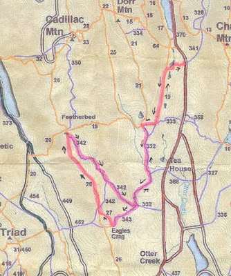
6/21/10 Eagles Crag Foot Trail and Potholes Path


The plan was to hike the Potholes Path from the bottom rather than from the top which we had done. We started at the Canon Brook Trail head (19) and took that to the Dorr Mtn. S. Ridge Trail . The Dry Mountain Path Extension (332) starts across the trail behind some fallen trees. We took that to the intersection of the Eagles Crag Foot Trail (343) and the Potholes Path (342). We took the Eagles Crag Trail, thinking to do it and then return to the intersection to do the Potholes. After reaching the base of Eagles Crag the trail became steep and rocky and presented problems for Kelley. We did make it up, with Kelley needing a couple of boosts , but I did not want her to have to go back down that trail so we decided to make a loop of it and continued on Cadillac Mtn. S. Ridge (26) to near the Featherbed where we picked up the Potholes Trail which we took back to the intersection with Eagles Crag and then back the way we had come.

Near start of Canon Brook Trail

Eagles Crag Foot Trail

View from Eagles Crag

The Potholes Path. Much of it is open and , I think, a very nice trail


One of the potholes for which the trail is named. This one is 7 or 8 inches across.


A hot and humid day but still a great hike. 5 hours

Sunday, June 20, 2010

6/19/10 Western Mountains


A quite warm day so we decide the woods would be more comfortable than open ledges and went to the western side of the park. We parked at the pumping station and Kelley was in Long Pond before we even started the hike
On the way to Mill Field to start the Sluiceway Trail we took the short road to the reservoir which we had not visited. It was quite small, 50 x 75 feet and I don't know it's purpose as there seemed to be no pumping equipment or anything else.

The sluice way trail is mostly through pretty woods with some rocky sections but nothing difficult.

At Little Notch we turned toward Knight Nubble and great Notch. This is from an overlook near Knight Nubble

We knew from previous experience that this section of trail posed difficulties for Kelley but she has become braver and more skilled and managed it without help from me.

We took a short detour on the Razorback--just long enough to get the views


And then continued toward Mansell Mtn. which is wooded but has a nearby overlook.

Our next trail was the Perpendicular which also poses some difficulties for Kelley. As it's name indicates it is quite steep in parts and has sections of stone stairs winding along the side of the mountain.

Kelley managed all except this section of iron rungs where I gave her a hand

and we continued down to Long Pond.

At the Long Pond Trail we turned left and walked a half hour to our favorite lunch spot on the pond.

After lunch and a couple of swims (Kelley) we headed back down the trail to the pumping station and our car. 4- 1/2 hours