
Thirty degrees and sunny. Decided to head over to Franklin where there are several trails we do and see if we could access any of them. Myric Pond Rd, to Tunk Mt. Trail was not plowed. Dynamite Brook Rd. to Catherine, Caribou, and Donnell Pond trails was also not plowed. Hidden Pond parking lot not plowed and large snow bank preventing entrance. That left the rail trail back in Franklin. This is part of an 85 mile trail - only a portion shown above - and part of the proposed East Coast Greenway.
The trail had not had any recent snowmobile activity and only a few prints by walkers the footing was pretty good. Light snow over snow/ice with a very few bare spots.
Kelley quickly found some water


Taking a break while I take a picture

Card Mill Stream


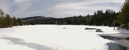
A side trail which leads to the end of ( I think ) Donnell Pond . This was a bit of a slog for me as the trail had not had much traffic. The crust supported Kelley.

A two shot pano of the pond - click for larger view
Real water for Kelley

After we shared an apple we headed back the way we had come. Not a bad hike, even though not as interesting as the alternatives. Kelley seemed happy with it. 2 3/4 hours

Hooray for sunny skies, melting snow, and water for Kelley's swim.
ReplyDeleteHi Linda - only for the day- last night we got a little more snow - will post tomorrow. But there will be an end- Kelley was very happy to find water she could get into.
DeleteThat whole trail system is very intriguing..which section of it that you've hiked crosses brooks or streams..can you guess where I'm heading with this?
ReplyDeleteI can guess. We have only done three sections, from Ellsworth there were a couple of streams ; this one from Franklin had the one stream, and I think there was a steam on the section from Rte. 183. Don't know if any have fish in them.
Delete