The Rest of Our Hiking Pictures Can Be Found Here

Finding Trail Descriptions

So as not to repeat myself excessively, I am reducing the amount of description of trails that have already been posted. Please use the search function ( upper left) to find older posts which have more detailed trail descriptions and pictures. You can also use this to find specific hikes either by trail or mountain.


Click Pictures for a Larger View


Friday, November 22, 2013

11/21/13 Blackcap Mountain

I have been unable to find maps of these trails so have adapted my own. Everything is, therefore, approximate- I believe the trails extend further east than shown .

The last time we were at the pond ( for Kelley to have a swim) I saw a new trail sign which was past the Blue and White Trail- see map.


and today we were going to check it out. It started out as a fairly steep woods trail with lots of leaves that were slippery.


We came to a clearing and the trail from that point was one we had been on before- at least parts of it. It was very rocky and poorly maintained with lots of uncleared blow downs . Kelley really struggled with this trail with numerous work arounds, some big bushwhacks, and several times when I had to lift her as there was not an easy way around- she resisted that but had no choice at times.


At one point the trees opened for a view of the pond below


but then it was back to it


We came to a junction with a trail blazed blue and white which I believe is the trail we usually descend on - we have always come up the Blue and White Trail and then down this end. We continued up and it became much easier


I had thought this hike was going to be too short and we would need to add something to it but it had taken us two hours to reach the ridge!

We found a nice spot to have our apple and some water


Unlike the woods coming up, which had mostly been deciduous, the trail along the ridge is  mostly through conifers


and a view from near the summit - which has six towers ( not shown)


We found the Blue and White Trail and descended to the pond, which made Kelley happy


And a final dip before we got in the car to head home


It had been an arduous hike but Kelley was very brave and resourceful and we felt good about our accomplishment. 3  1/4 hours

Thursday, November 21, 2013

11/20/13 Piney Knoll Conservation Area - formerly Marsh Island


A late start so we headed to nearby Orono. What was once Marsh Island Natural Area is now Piney Knoll Conservation Area with a new map. The old map was sometimes confusing for us and the new map continues to be so, and it's harder to read. I have not marked out our route as the middle on the outward bound section is a little hazy ( some new paint blazes but also sections with both blue and red flagging. - simple signs at intersections would make things easier)  coming back we did not get off track. We started at the Hillside Ave. entrance and went to the Penobscot. River and back. Kelley was happy in the woods and  tolerant of my missteps.

Some things we saw

Still some leaves in late November


Ducks were too far away for a good picture


Truckin'

The river looked high even though streams are low


Queen Anne's Lace- one of my favorite plants to photograph


A pleasant 2 hour outing- a bit cool but supposed to be warmer tomorrow.

Wednesday, November 20, 2013

11/19/13 Redmans and Schoodic Beaches


Yesterday was rain and Kelley went to visit at the nursing home. This morning is cold ( 34 at start 36 at finish). quite windy, and gray- though the sun was in and out by the time we got to our hike. We had done the old woods road/path from the end of Dynamite Brook Road several times but recently learned about another old road that went from Redmans ( called 'Black' on above map)  to Schoodic Beach and we decided to look for that.

Though an old woods road, it narrows in places


and Kelley soon found a stream


We found what looked like relatively new flagging on a rough trail we hadn't noticed before. We followed it for awhile and it took us near another part of the pond before petering out ( question mark area on map). Instead of backtracking we bushwhacked up the hill to the trail we usually use and continued on to Redmans Beach


After Kelley had a swim we looked for the other old road and soon found it. It was eroded in places  and in good shape in others


By the time we reached Schoodic Beach and camp ground it was clouding up again and the wind had picked up considerably. Kelley does not like waves so she passed on a swim here.


To get back to the path we came in on we used one of the trails within the beach complex


Nearly back and we got nice sunny skies


A pretty good hike.We were in the woods most of the times and protected from the cold winds, we found the path we sought, Kelley was happy to be back in the woods.  3  1/4 hours
Monday, November 18, 2013

11/17/13 Downtown Bangor

I felt like a day off and there was a ( slight) chance of rain so we just went downtown for a walk. Kelley is usually pretty interested in all the smells around town and greeting people. But today, even though I let her pick the route, she was not enthusiastic and didn't take long to lead us back to the car. I don't know if she wanted an easy day too or was disappointed we weren't in the woods.

I had only time for a few pictures.


Sunday, November 17, 2013

11/16/13 Mansell Mountain


A hike with our friend Faith and her dogs Roxie and Gus. We were going to hike the West Ledge Trail of Bernard  but when we arrived at the gate on Seal Cove Road we found it already closed and didn't want to do the long walk to the trail head. Instead, we drove to Long Pond and hiked Mansell.

Some fishermen on the pond


I told Faith that the Mansell trail was not steep and didn't have views. It had apparently been awhile and I was wrong on both counts.

View from the trail


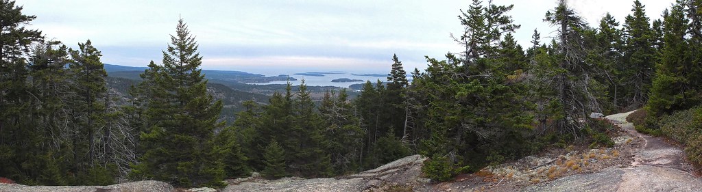
a bit further up- pano- click for large version

Mansell Mtn.  11-16-13

Faith against another view


Maybe she has treats


Gus


Roxie


Two by Faith- Kelley not cooperating, as usual


In her comment Faith asked where I was, so I added this one that  she took- I don't know what I'm doing with my arms but Gus is paying attention.


The climb was steeper than I remembered and there were some work arounds for Kelley but she managed them OK . When we reached the summit we decided to go over to Great Notch and take that trail down. At the notch there was a group of women resting and they liked the dogs and the dogs liked them.

Coming down Great Notch Trail


A pretty good hike in spite of change of plans, my misinformation, and the non appearance of sun and warmth that had been forecast . The dogs all got a good work out and we enjoyed the beauty of the woods and views.  3 hours

Saturday, November 16, 2013

11/15/13 Eliot Mountain and Harbor Brook


Something a little less arduous than yesterday's hike. We started from the trail head on Rte. 3 with several possible hikes in mind.


We came to the trail that leads to Thuya Gardens and never having taken it we decided we would. I expected that they would be closed and would not allow animals and this was the sign on the gate


Kelley didn't have five bucks anyway.

When we reached the summit we decided on the trail down to the old map house and start of the Asticou trail


After an apple break we took the Asticou across to the Harbor Brook Trail , one Kelley likes because of the stream it runs along side of.


And I found some pretty lichens


There is a spot just off the trail where we usually stop for lunch and Kelley always goes right to it.


After lunch we continued on down the trail . Though the stream was mostly quite low there were plenty of pools for Kelley to get into.


These leaves on the bottom of the stream had an odd silvery color


An example of how low the water was in some sections


Near the end of the trail


When we reached the road we had a short walk beside it to our car. A good hike- it was in the 40's and mostly cloudy rather than 50 and partly cloudy predicted - but comfortable enough . 2  3/4 hours