The Rest of Our Hiking Pictures Can Be Found Here

Finding Trail Descriptions

So as not to repeat myself excessively, I am reducing the amount of description of trails that have already been posted. Please use the search function ( upper left) to find older posts which have more detailed trail descriptions and pictures. You can also use this to find specific hikes either by trail or mountain.


Click Pictures for a Larger View


Wednesday, January 30, 2013

1/29/13 Jordan Pond Area


Sunny morning with no wind- still below freezing but supposed to warm considerably the next two days and rain!  We wanted to get in a good hike before the rain but didn't know what the trail conditions would be. Our first attempt was St. Sauveur from the highway which we had not done in a long time. The unplowed parking area should have been an omen but we started up. It was extremely icy - Kelley looked at me as if to say, " we aren't really going to do this?" And we quickly gave up. I thought the carriage roads around Jordan Pond would provide descent footing and they are some of the more interesting. But when we got to them Kelley wanted to do the Asticou Trail which is mostly flat and had good footing with only a few icy patches and even some bare spots.


When we crossed the second carriage road I thought we might check out the Penobscot Trail. but we only got a short distance before we reached a point that Kelley won't climb and makes a large bushwhack around. I decided to skip that and return to the carriage roads. It was really a pretty day and I took a lot of pictures. Please excuse the excessive  number of carriage road pictures.


I had not printed out a map of this area as it wasn't in the plan ( I print out the section we will hike so I don't have to dig out the large map)  and as we wandered the roads I realized when I switched backpacks I neglected to transfer the regular maps. Nevertheless, we got back to the Asticou and took that back to Jordan Pond and the carriage road I had originally intended.

This door is on a very small brick building by the stream.


This section of carriage road runs between Jordan Pond and the crumbling Jordan Cliffs above. The footing was very good- mostly packed snow with little ice.


Jordan Pond from the road


I'm not sure about this. It appears to be the remains of the inner part of an old tree- it was about 3 feet across


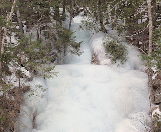
 Frozen water running down from the cliffs


A couple of pics of Kelley waiting for her portion of lunch


One last road picture as we head back to the car- clouding up at this point


Turned out to be a beautiful day and nice walking once we got to the pond area.  3 hours

Tuesday, January 29, 2013

1/28/13 Snowmobile Trails

Late start as I had some other  things to do this morning. By the time we got started it was a 'balmy' 18 degrees with sun and no wind. Very pleasant  after several days of below zero wind chills. The footing was very good with only a couple of icy section to walk around. We even met a man on a bike.

These lichen were atop a fence rail


We followed that side trail we had started the other day and, while quite nice,  it only led to someones back yard and a 'private property' sign.


We did find this nice stump


From the end of that trail we returned the way we had come


It had clouded up by the end but still a very pleasant walk. 2  3/4 hours

Sunday, January 27, 2013

1/26/13 Breakneck and Carriage Roads


Still cold but sunny and not quite as windy. Still looking for somewhat sheltered trails. Decided to make a loop of part of the Breakneck and some carriage roads. We started at the Hull's Cove end of the Breakneck . It receives a good amount of use ( though we met no one today) and was quite icy but with space beside the trail to walk in the snow.


The stream crossing was a little hairy- frozen over ( usually you have to balance on rocks) with glare ice and, in spots, you could see water running below the ice. We made it safely across- Kelley was also hesitant because she doesn't like slippery.  Once across the stream the  trail starts a gradual ascent and there had been  much less traffic -there was little ice with hard packed snow instead- good walking.

When we reached the ponds we moved over to the carriage road and it was also packed snow with little ice.


We followed the loop indicated on the map. At one point there is a bridge over Duck Brook which gives access to the carriage roads from  Duck Brook Road. This is a view of the brook from that bridge


Kelley was standing looking at the ocean but by the time I got my camera out from beneath my coat she had moved and would not repeat the pose.


Near the end we took a short detour to get a good look at Witch Hole Pond and then turned and continued on to the visitor center parking lot. The last section was also very icy but , again, with snow on the sides to walk on. Kelley had checked every pond and stream but was disappointed to find them all frozen. After checking one last pond near the end she caught the scent of a couple ( the only people we met on the hike) and was off to great them. They gave her some attention and we continued on to the parking lot and a service road to Rte. 3 which took us back to the Breakneck. A pretty good hike in spite of the cold- the sun helped.  3 hours.

Saturday, January 26, 2013

1/25/13 Glenburn Trails


By 10:30 up to 10 degrees with a wind chill advisory but nice sunny skies. We decided on the short drive to the more wooded trails in Glenburn- they would give us more protection from the wind. First we went east from Lancaster Rd.


but when we got to Hudson Rd. we realized we would have a long stretch of windy open meadow and turned back.

There was a trail along the tracks but after going a short distance it looked like it also remained in the open.


Back across the road to the trail heading west- both pretty and protected


We crossed the Lancaster Brook which was slippery but seemed solid


but were reluctant to cross the Kenduskeag


instead we followed the trail north  along the stream as far as the road and came across a turtle shell in the middle of the trail- something of a mystery


 Normally I photograph things as I find them but this one I had to flip over for a picture of it's top


and a little later this ( apparent)  dog toy - also an odd find


When we neared the road when returned to the main trail but then followed a trail south that had not been used by sleds and found a sunny sheltered spot to have our lunch and then headed back


 A  good hike - it was really pretty nice if you avoided the wind and Kelley was happy with lots of new things to explore ( our first time on these trails this winter) . 2 hours


Wednesday, January 23, 2013

1/23/13 Snowmobile Trail and Bomarc

Even colder today-  2.5 with a wind chill of -15 and  a predicted high of 5 when we left the house. When we returned -after 11:00 the temperature, rather than rising , had dropped to  -0.7 . We managed to get in an hour and a half without losing toes or fingers ( Kelley was happy and did not seem affected and thinks I'm a woos) . We took the trail behind the house to a side trail ( non-snowmobile) - the crust was firm enough to make the walking OK.


Kelley was happy with this because this was the first time on this trail this winter and she likes variety. When we came to the fork in the trail we took the one toward Bomarc ( a former missile site-now a small industrial park) for more variety.


After wandering around there for a bit we went through some woods to the trailer park and through that back to the snowmobile trail and that took us home.

Tuesday, January 22, 2013

1/22/13 Brrrr

Very cold here ( 3 degrees when we walked this morning) and  no sun today.  Yesterday we just did an hour's walk north in the morning and then a hour south in the afternoon and there was sun which gave  a psychological boost if nothing else.  This morning it was north again. Kelley does not seem to mind the cold and we are getting in  her needed exercise.  Yesterday I didn't take my camera- this morning I took it with me but was reluctant to remove my mittens or unzip my jacket so no pictures. It looks like we have about a week of this before it warms a little. Time for the couch and a good book.

Monday, January 21, 2013

1/20/13 Canon Brook


Temps in the 40's today but supposed to be very cold the next few days which means lots of ice from the melting snow. Picked the Canon Brook Trail today because there are several alternatives, depending on the conditions we find. Plan is to do part of  Dorr, the Dorr  extension, and part of A. Murray Young.

We started from the trail head on Rte.3 along the Tarn Trail which turns into the Canon Brook. The bog bridge section had several downed trees- not the work of the wind but of beavers


You can see their lodge in the back of the pond


We did not get far on the Dorr S. Ridge Trail as we soon hit icy rocky sections that were a problem for Kelley. We turned back and followed the extension ( a no longer maintained trail added to the above map) to Otter Creek. No one had been on this trail but it is flat and easy to follow if you know it is there.


We did not attempt to cross it today ( we sometimes do the Pothole Trail from there) but returned to the Canon Brook and took that to the A. Murray Young. This is a trail we only do part of because there is a section of steep very large boulders without a work around for Kelley- we did it once with me boosting her but she hates that .  It's a pretty trail beside a stream but today had more ice than the other trails we had been on. Still, we made it to the place we usually turn around.


 This memorial is attached to a huge boulder


Once back at the Canon Brook we stopped at our favorite lunch spot in this area and then headed back to our start. Some things along the trail


An interesting hike - we were not in the open much so the wind did not bother us and there was lots of variety.  We avoided anything stressful for Kelley ( or me) and she  found several spots to get into the water but we met no other hikers.  3 hours